Morro de São Paulo: Exploring 6 Historical Buildings
|
Getting yours Trinity Audio Player ready... |
Morro de São Paulo holds centuries of history in its buildings, from the Portaló to the Lighthouse. In this guide, you will learn about six of them: Portaló, Casarão, Fortaleza, Fonte Grande, Igreja de Nossa Senhora da Luz, and the Lighthouse. The information comes from official sources, period documents, and local signage.
Origin of the Name of Morro de São Paulo
When the Europeans arrived, the region was inhabited by the Tupinambá indigenous people. On March 24, 1531, Martim Afonso de Sousa's expedition sighted the mouth of the Tinharé River, according to Pero Lopes de Sousa's diary . The region would later become part of the Captaincy of Ilhéus, one of the divisions of the Brazilian coast established by the Portuguese King Dom João III as part of the colonization system of Brazil in the 16th century.
It is presumed that the name comes from the expedition of the Castilian Francisco Romero, appointed by Jorge de Figueiredo Correia, grantee of the Captaincy of Ilhéus since 1534, to occupy and colonize the region. The charter was signed in March 1535 and, adding the preparation of the expedition and about two months of travel, Campos calculates that Romero would not have arrived before the end of September or the beginning of October 1535. As navigators used to name places after the saint of the day of their arrival, the historian João da Silva Campos considers January 25, 1536, the Day of the Conversion of Saint Paul, to be the most likely date, and warns that this is a supposition, as it is not known when the name began to appear on maps and itineraries.
Morro de São Paulo became the capital of the Captaincy of Ilhéus and was the first settlement in the captaincy. Later, the capital was transferred to another location, but the name Morro de São Paulo remained.
Historical Buildings in Morro de São Paulo
Portal of Morro de São Paulo
The Portaló is the large masonry gate, with an arched opening, that provides access to the fortified enclosure. The name comes from nautical vocabulary, where it designates the opening in the ship's side. On the outward-facing pediment is the colorful coat of arms of the Brazilian Empire.
For those arriving on the island, the Portaló is the first historical structure one passes: one crosses the Portaló and climbs up to the village. Those in the village who want to go to the fort descend the slope from the arrival point to the Portaló and continue on foot, following the wall, passing the first curtain wall, the Battery of Our Lady of the Conception, where there are cannons, and the second curtain wall until reaching the fort.
According to the fortress's signage, the curtain wall, stretching 678 meters along the canal, was built starting in 1728, by order of the Count of Sabugosa. An inscription on the Portalo (gateway) records that, in 1863, during the reign of Dom Pedro II, the fortress was rebuilt.
The Mansion on Morro de São Paulo
The Casarão is a two-story house from the colonial period. According to the Casarão itself, it was built between 1608 and 1616 by the Saraiva family. Today, restored, it operates as an inn and restaurant.
Morro de São Paulo Fortress
The Morro de São Paulo Fortress, also known as the Morro de São Paulo Fort, São Paulo Fort, or Tapirandu Fortress, was listed as a national heritage site by IPHAN on May 24, 1938 (process 155-T-1938), with registration in the Historical Heritage Registry (no. 46) and the Fine Arts Registry (no. 91).
According to the site's signage, construction of the Old Fort, or Battery of Our Lady of the Conception, began in 1630, by order of Governor Diogo Luís de Oliveira. Historian João da Silva Campos places the start of construction in 1631, after the governor's visit to the island in 1630. A decree from this governor, dated September 10, 1631, appointing a quartermaster for the Fortress, explains the reason for the work: there was a warning that the Dutch intended to settle on the hill, and the governor ordered it fortified before the enemy occupied it. Between 1728 and 1732, the Count of Sabugosa ordered the Fortress to be expanded. In 1823, during the Independence of Bahia, Lord Cochrane established the base of the first national squadron there.

See the plant legend, letter by letter.
Caption based on the catalog of the Overseas Historical Archive, with language adapted for today's reader.
The plant is painted in watercolor, in the colors green, blue, brown, red, and yellow.
Miguel Pereira da Costa details the fortification. The plan reads:
A – Entrance to Barra.
B – A flat bastion with seven mounted artillery pieces; as the area is small, they cannot operate simultaneously.
C – Guardhouse and captain's quarters.
D – A section of wall with seven artillery pieces that rotate across the terrain, for the defense of the port.
E – Portaló (in the catalog, “Portalô”), opposite the place where boats appear (anchor).
F – Ascent made via steps on the terrain.
G – A section of the fortification wall, built 20 years ago (at the time of the plan), still imperfect and without a platform (the platform at the top of the wall where the cannons are located).
H – A battery located two-thirds of the way up the hill, with five artillery pieces rotating above the ground, at a height of 200 palms (approximately 44 m) from the beach. This level is the same as that of the wall. G, a single line runs around the hill (in the original, “sweeping the hill”) on the terrain, along which they wanted, at that time, to build a parapet along its entire length to encircle (surround) the hill, and, at certain distances, some batteries, such as I...at the tip of the trunk. But experience shows the poor stability of the terrain, which has been deteriorating significantly in recent years.
I – Battery at the tip of the trunk (mentioned in H), in the location where the Ponta Fort is today.
L – A house that serves as a gunpowder warehouse.
M – Chapel of Our Lady of Light, on the highest mountain.
N – Chaplain's residence at the prison (military garrison, not a prison).
O – Battery just as incompetent (inadequate) as the others.
P – Ilhote do Caetá (today, Ilha do Caitá), “sobreaguado de preamar” in the original, meaning above the water at high tide.
Q – Small port (anchorage) where the freshwater stream enters, at the site of the current Primeira Praia (First Beach).
R – Houses where the soldiers from the prison live.
S – A new battery is proposed, to be installed at the tip and entrance of the Barra, which fully protects the channel.
T – Part of the shallows (lowlands) on the mainland side.
Emperor Pedro II visited it in 1859, during a trip through the Northeast with Empress Teresa Cristina, and found it dismantled: according to him, there were few usable pieces and the sea had already knocked down part of the wall. It was rebuilt in 1863 and reopened in January 2018, after requalification. In 2019, IPAC announced the provisional listing of the perimeter of the lighthouse, the fig tree, the Portaló, the square, the church and the Fortress itself.
Fonte Grande do Morro de São Paulo
According to the inscription on the fountain itself, the viceroy, Count of Galveias, ordered the work to be done in 1746. Dom Pedro II, who visited it in 1859, transcribed the inscription in his diary with the date 1743 and described it as a public fountain with three spouts. The water served the soldiers of the fort and the inhabitants of the village.
Our Lady of Light Church
According to the signs at the Fortress, the original chapel was erected on the hilltop in the early 17th century, at the initiative of a member of the Saraiva family. The current church was built further down, at the foot of the hill, between the late 18th and early 19th centuries, and the date 1845 is inscribed on the facade. In 1859, Dom Pedro II visited it and noted the sisterhood of the saint and a votive offering from sailors in the sacristy.
On the church floor are tombstones of villagers; the inscriptions that can still be read date from the beginning of the 20th century. A small glass door, to the right of the altar, displays a dental arch found during a restoration; the complete story is in Mysteries and Curiosities . The church was the target of a recorded theft: in 1782, the magistrate found the church's safe empty, emptied, according to the historian João da Silva Campos, by Captain-Major Antonio Caldas. During the restoration of the Fortress, fragments of stonework were found which, according to the signage, would have belonged to the pediment of the original chapel.
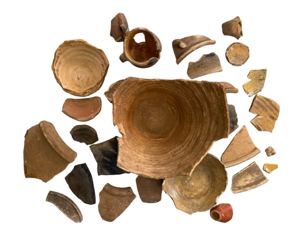
During construction work behind the church, builders found archaeological materials, and an archaeology team was called to the site. The rescue program was already carrying out educational activities in September 2021, and the collection was presented in an exhibition in April 2022. Follow the church on Instagram.
Sao Paulo's Morro Lighthouse

Morro de São Paulo: The 11 Essential Items for an Unforgettable Trip
The lighthouse was inaugurated in 1855, according to the plaque from the Brazilian Navy installed at the site. The work was carried out by the engineer Monteiro Carson, from the Fábrica Todos os Santos factory in Valença, according to the signage at the Fortress and the diary of Dom Pedro II. Today it serves as a navigational aid operated by the Navy, standing 26 meters tall, 89 meters above sea level, and emitting a white light that reaches 23 nautical miles.
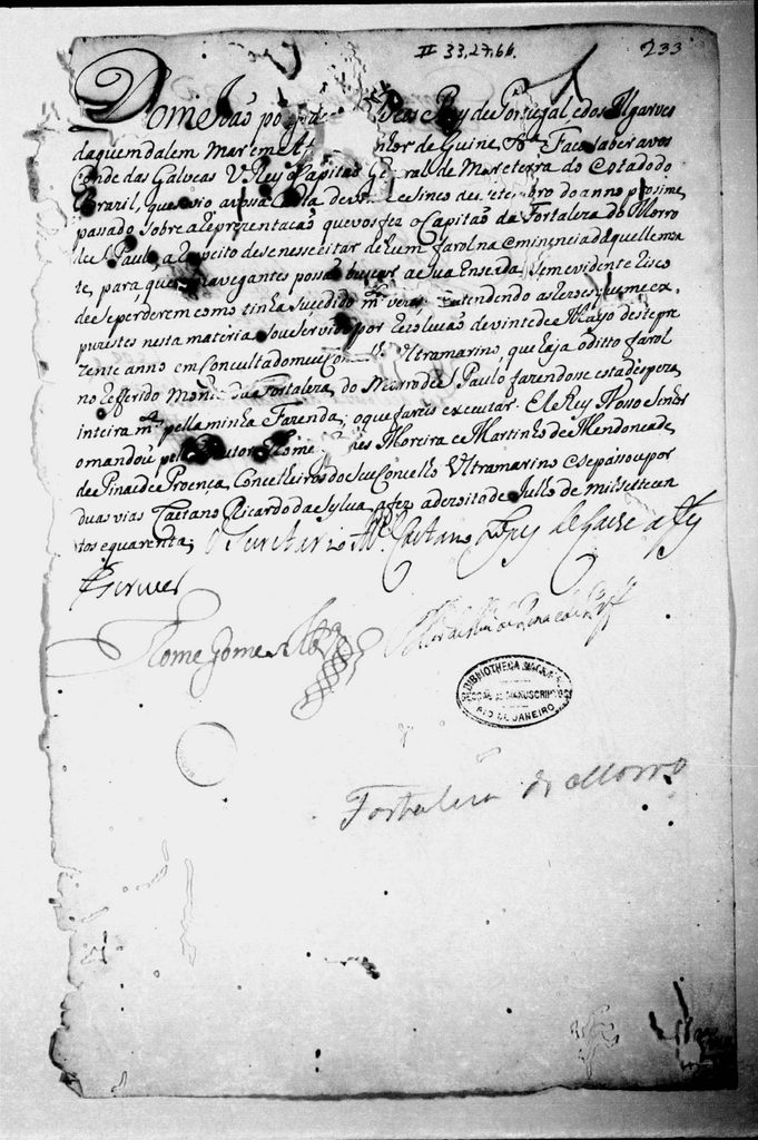
The idea of a lighthouse on the hill is much older. On July 18, 1740, a royal decree ordered the viceroy, Count of Galveias, to build a lighthouse atop the hill, at the request of the captain of the Fortress, with the expense paid by the royal treasury. The objective was to allow navigators to find the bay without the risk of getting lost, as had happened many times before. The current lighthouse, however, is the one inaugurated in 1855.
In 1859, Emperor Pedro II visited the lighthouse and noted in his diary:
The tower of this lighthouse is 74 feet high and is reached by 74 stone steps and 4 wooden steps, followed by two flights of 33 wooden steps and 1 stone step to the balcony surrounding the lantern, from where one enjoys an excellent view […]. There are 9 iron steps inside the lantern to reach the lighthouse apparatus, which is of the Fresnel system, and manufactured by Henry Lepante, Paris. […] It is intermittent and the revolution is 12 minutes. It consumes 124 layers of oil over three months, being sweet, from purified castor oil, or coconut oil; it is now served sweet […].
Quote attributed to: Dom Pedro II, diary, October 5, 1859
According to the timeline displayed in the church, the Navy installed a radiotelegraph station there in 1943. In 2024, the Navy carried out complete maintenance on the tower ( read the article ).
How to Visit Historical Buildings
- Portaló: It's located at the entrance to the hill and is part of the path for those arriving on the island. The walk to the fort starts from there.
- Fortress: Currently, interior visits are not available. From the outside, you can see the wall, and access to the exterior area is free. The location is one of the best spots for watching the sunset.10 unforgettable experiencesWhen internal visits reopen, we will publish the schedules.
- Church of Our Lady of Light: Entry is free and it is usually open from 6 am to 22 pm. Inside there is a timeline with the history of the island. According to the church, mass is on the second and last Saturday of the month at 19:30 pm; on other Saturdays there is a celebration of the Eucharist.
- Large Fountain: It is located outdoors and can be viewed at any time.
- Lighthouse: You can't climb the tower. The visit is external and during the day, because there is no lighting along the way. Nearby is the Zimbeiro Battery, the zip line viewpoint, where part of the structure collapsed in May 2024.Learn moreThere is also the lighthouse lookout point, made of wood, where the happy horn is located (10 unforgettable experiencesBe careful at the Zimbeiro Battery.
St. Paul Hill Today
A few decades ago, small fishermen's houses were built, and locals say that their livelihood was mainly based on fishing. Morro de São Paulo was a small village where there was no telephone or electricity. According to the oldest residents, electricity only arrived on the island in 1985!
In the 70s, when the first summer visitors arrived, the quiet village had no idea what was to come. Summer visitors, who rented the fishermen's houses, began building their own vacation homes. And when backpackers and hippies discovered the place, they spread the word about its beauty and charm. Then, tourists arrived, and the houses in the small village were transformed into hotels, guesthouses, and restaurants.
Currently, Morro de São Paulo is a destination that attracts both foreigners and people from all regions of Brazil, resulting in a multicultural community that enriches the place with an incredible diversity of art, culture, and gastronomy. With this fusion of influences, Morro de São Paulo enchants its visitors by harmoniously intertwining its historical past with the vibrant energy of the present, providing a truly enriching and fascinating experience.
Sources: Pero Lopes de Sousa, Diary of the Navigation of the Armada that went to the Land of Brazil (expedition of Martim Afonso de Sousa, 1530–1532), ed. Varnhagen, Rio de Janeiro, 1847, entry of March 24, 1531; Overseas Historical Archive, plan of the fortifications of Morro de São Paulo, c. 1725 (AHU_CARTm_005, D. 0963), and letter of 8/1/1725 (AHU_ACL_CU_005, Cx. 20, D. 1822); diary of Dom Pedro II, entry of 5/10/1859 (Imperial Museum); Letters to Their Majesties (National Archive, 1977); João da Silva Campos, Chronicle of the Captaincy of São Jorge dos Ilhéus (1936); Oliveira (2011), “The defense of the Bay of All Saints”, in Bay of All Saints: human aspects (EDUFBA), pp. 188–199, which transcribes the provision of 10/09/1631; royal letter to the Count of Galveias, Lisbon, 18/07/1740 (National Library, Manuscript Division, II-33,27,66); IPHAN (record of the Morro de São Paulo Fortress, process 155-T-1938); Brazilian Navy (lighthouse plaque); signage of the Fortress (Bahia Turismo and steel plaque of 2023); inscriptions of the Portal and the Fonte Grande; information from the Manor House itself; information and timeline (2012) exhibited in the Church of Nossa Senhora da Luz; exhibition “Archaeology in Morro de São Paulo” (@arqueologos, April 2022); Correio, “Historic buildings in Morro de São Paulo will be listed as heritage sites”, 09/20/2019.
Traveling to Morro de São Paulo? Connect with other travelers in the Explore Morro groups. On WhatsApp and Facebook you can ask questions, exchange tips and plan tours. And Telegram is our meeting point: if Facebook or Instagram goes down, that's where we'll meet. Join via the link direct.me/exploremorro and tap on Groups.